New Technology: Analysis of Mineral Prospecting Effectiveness Using Spread Spectrum Induced Polarization (SSIP)
Analysis of exploration effect of spread spectrum induced polarization (SSIP) method——Taking the exploration of Dongxiangqiao manganese deposit in Lingling district, Yongzhou City,Hunan Province as an example
LIAO Fengchu1, LIU Guiyuan1, ZHOU Jie1, HUANG Jianquan1, XU Junwei1, CHEN Rujun2,3,4,5
1. Hunan Institute of Geophysics and Geochemistry, Changsha 410116, Hunan, China;
2. School of Geoscience and Info-Physics, Central South University, Changsha 410083, Hunan, China;
3. AIoT Innovation and Entrepreneurship Education Center for Geology and Geophysics, Central South University, Changsha 410083, Hunan, China;
4. Key Laboratory of Nonferrous Metal Mineralization Prediction and Geological Environment Detection of Ministry of Education, Changsha 410083, Hunan, China;
5. Hunan Key Laboratory of Non-ferrous Resources and Geological Disaster Exploration, Changsha 410083, Hunan, China
First author: Liao Fengchu, senior engineer, engaged in mineral exploration and geology for a long time.
Corresponding author: Zhou Jie, senior engineer, engaged in geophysical exploration for a long time.
Overview:
Currently, a large number of induced polarization (IP) surveys rely on time-domain pulse power supply, which requires extended saturation charging of deep-seated target bodies to acquire reliable secondary field information. Moreover, manual adjustments of the AB electrode spacing are often needed to probe at various depths, which complicates traditional IP measurement technology. This method faces challenges including high difficulty of field work, low efficiency, high cost, weak signals from deeper layers, and limited depth penetration. In response, Chen Rujun et al. have innovated both instrumentally and methodologically, integrating spread spectrum communication signal processing and weak geophysical signal acquisition technologies to develop the Spread Spectrum Induced Polarization (SSIP) technology and equipment. SSIP offers deep penetration, high precision, strong anti-interference capabilities, lower costs, and higher efficiency, enabling induced polarization parameter acquisition within a range of 1000 meters.
This paper presents the principles and working methodology of the Spread Spectrum Induced Polarization (SSIP) technique, as well as its application in exploring the Dongxiangqiao manganese deposit in Lingling District, Yongzhou City, Hunan Province. A relatively continuous high polarization anomaly zone was identified, with resistivity inversion results showing a "U"-shaped high-resistance basement encasing a low-resistance core, suggesting that the high polarization anomaly zone is likely caused by an underlying mineral deposit. Subsequent drilling uncovered two relatively continuous manganese ore layers, with thicknesses ranging from 0.9 to 2.8 meters and grades between 9.3% and 15.2%, which co-occur with pyrite within limestone formations. The apparent polarization anomalies matched well with the depth, shape, and contour of the exposed ore bodies, and the apparent resistivity anomalies effectively reflected the stratigraphic distribution in the mining area. The efficacy of SSIP for carbonate manganese ore prospecting has thus been validated.
Funding:
This work was jointly funded by the Natural Resources Ministry's project for supporting scientific and technological breakthroughs in the latest mineral exploration strategic action (ZKKJ202407) and the Hunan Geological Institute Research Project (HNGSTP202402).
Contents
0 Introduction
1 Geological and Geophysical Characteristics
1.1 Geological Characteristics of the Mining Area
1.2 Geological Characteristics of the Ore Bodies
1.3 Geophysical Electrical Characteristics
2 Basic Principles
3 Technical Parameter Settings and Inversion
4 Results Interpretation
5 Drilling Results
6 Conclusion
0. Introduction
Geophysical exploration plays an essential role in the detection of deep-seated concealed mineral deposits. In areas with complex geological settings, combining multiple geophysical exploration methods often yields better prospecting results. This is due to the variable grades, scales, and discontinuous nature of ore deposits, which often result in minimal resistivity contrasts between ores and surrounding rocks. Therefore, relying solely on resistivity measurements may not produce satisfactory outcomes. Unlike single apparent resistivity methods, the IP method, which simultaneously measures apparent resistivity and polarization parameters, can more effectively detect anomalies caused by disseminated metallic sulfides in most cases. Since the IP method is less influenced by topography, its anomalies are often more reliable than those of resistivity measurements.
However, most IP measurements currently employ time-domain pulse power, where secondary field detection of deep target bodies depends heavily on prolonged charging duration. Moreover, manual adjustment of the AB electrode spacing is required to achieve depth profiling. These factors make traditional IP measurement methods challenging, inefficient, costly, with weak signals at depth, and limited depth penetration.
To address these limitations, Chen Rujun et al. (2020) made significant innovations in instruments and methods, creatively integrating spread spectrum communication signal processing technology and weak geophysical signal acquisition technology. They developed the Spread Spectrum Induced Polarization (SSIP) technology and equipment. This technology has deep penetration, high precision, strong anti-interference, low cost, and high efficiency. It allows the measurement of IP parameters within a 1000-meter depth, effectively identifying anomalies associated with non-ferrous metal mineralization. This technology has been effectively applied in various mineral exploration projects across Tibet, Gansu, Yunnan, Guizhou, Henan, and Jiangsu in China.
To date, the application of the SSIP pole-dipole technology in carbonate manganese ore exploration is limited. This study uses SSIP technology to explore the Dongxiangqiao manganese deposit in Lingling District, Yongzhou City, Hunan Province. Multiple borehole drillings later verified that the IP anomalies correlated well with the depth and morphological characteristics of the ore bodies, providing a strong demonstration for utilizing this technology in similar geological contexts for future exploration. Hence, the use of SSIP in carbonate manganese prospecting within the Qiling Basin has important application value.
1. Geological and Geophysical Characteristics
1.1 Geological Characteristics of the Mining Area
The mining area is located in the south-central part of the Qiling Basin, within the northeast-southwest trending Qiaomaichong-Dongxiangqiao complex syncline (Figure 1). The overall structure is a syncline, with symmetrical development of strata on both wings. The exposed strata primarily include the Carboniferous (C), Permian (P), and Quaternary (Q4) formations. The Carboniferous stratum belongs to the Hutian Group (CPH), distributed on the east and west sides, which is left and right wings of the syncline of the mining area, and consists mainly of dolomite and dolomitic limestone. The Permian stratum includes the Upper Permian Longtan Formation (P3l), Middle Permian Gufeng Formation (P2g), Xiaojiangbian Formation (P2x), and Qixia Formation (P2q). The Upper Longtan Formation (P3l) is characterized by mudstone and shale in the central part of the mining area, forming the syncline core. The Middle Permian Gufeng Formation (P2g)—Qixia Formation (P2q) are distributed symmetrically on both wings, forming a parallel conformable contact. The Gufeng Formation, consisting of carbonate rock facies, is the main layer for manganese mineralization. The Xiaojiangbian Formation and Qixia Formation are mainly siliceous and dolomitic limestone. The Quaternary (Q) strata comprise weathered and residual deposits distributed along slopes and valleys, with thicknesses ranging from 0 to 20 meters.
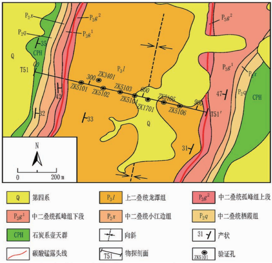
FIG. 1 Geological map of the study area
The structural framework of the mining area is relatively simple, mainly consisting of the Dongxiangqiao syncline in a northeast-southwest orientation, accompanied by minor east-west faults. This syncline, located in the southern segment of the Qiaomaichong-Dongxiangqiao complex syncline, controls the distribution of manganese ore within the area.
1.2 Geological Characteristics of the Ore Bodies
(1) Stratigraphic Control on Carbonate Manganese Ore
The presence of favorable mineralized strata is a fundamental condition for the carbonate manganese mineralization in the area. The manganese ore primarily occurs within the upper section of the Middle Permian Gufeng Formation, comprising mudstone-bearing limestone with abundant mud and algal residues. The underlying formation consists of relatively pure limestone with low manganese content, where carbonate manganese mineralization is largely absent. Thus, the bioclastic-rich impure carbonate strata in the upper Gufeng Formation control the occurrence and distribution of carbonate manganese ore.
(2) Structural Control on Carbonate Manganese Ore
Structural control of carbonate manganese ore is evident in both regional metallogenic processes and specific deposit formations. Geological data indicate that the Qiling Basin, as a manganese-bearing basin, developed under the control of multiple deep-seated fault sets. Within the basin, north-south trending secondary synclines control the distribution of manganese ore deposits and influence the orientation, form, and distribution of ore-bearing layers. This demonstrates the multi-scale structural control over manganese deposits in the area.
(3) Depositional Control on Manganese Ore
The Gufeng period saw the deposition of iron and manganese rich siliceous rock, carbonate, and mudstone. Due to the chemical decomposition of materials from adjacent ancient lands (Jiangnan and Xuefeng ancient lands) and volcanic zones, silicon dioxide, manganese, and iron flowed into the basin. Additionally, abundant radiolarians and siliceous sponges flourished in both surface and seabed waters, leading to the formation of manganese (and iron-manganese) deposits. The manganese in the ore mainly appears as rhodochrosite, showing a close association with algal fossils, forming granular structures that indicate the relationship between the two. The Gufeng period likely represents a lagoon and tidal flat depositional environment.
1.3 Geophysical Electrical Characteristics
The main lithological components of different strata from shallow to deep include Quaternary (Q4) gravel-bearing clay; Upper Permian Longtan Formation (P3l) mudstone, shale, and sandstone; Upper section of Middle Permian Gufeng Formation (P2g2) mudstone-bearing limestone, pyrite, and manganese ore; Lower section of Middle Permian Gufeng Formation (P2g1) siliceous limestone and dolomitic limestone; Middle Permian Xiaojiangbian Formation (P2x) siliceous rock and limestone; Middle Permian Qixia Formation (P2q) limestone intercalated with shale; and Carboniferous Hutian Group (CPH) dolomitic limestone. The electrical characteristics of the lithology in different strata are shown in Table 1.
Table 1 Statistics of formation resistivity and IP parameters in the test area
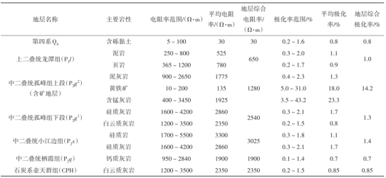
As shown in Table 1, due to the significant resistivity differences among the rocks within the ore-bearing strata, there is a notable resistivity contrast between these and adjacent layers. Relying solely on apparent resistivity measurements, it is challenging to determine the subsurface characteristics of ore-bearing layers, greatly impacting prospecting effectiveness. However, both manganese-bearing limestone and associated pyrite exhibit pronounced high polarization features, resulting in an integrated polarization rate of 14.2% in the ore-bearing strata, compared to an average polarization rate of 1.4% or lower in other strata, creating a 10-fold difference.
Thus, the ore-bearing strata have medium resistivity and high polarization electrical characteristics, providing a strong physical foundation for utilizing IP measurements in deep prospecting.
2. Basic Principles
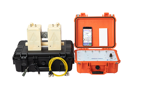
The Spread Spectrum Induced Polarization (SSIP) system uses a wireless distributed high-precision array for data acquisition, transmitting frequencies from 1/256 to 8192 Hz, with frequency ranges varying from 4 to 256 depending on modulation order. The system employs an M-sequence pseudo-random spread spectrum signal from the transmitter, greatly enhancing frequency domain resolution and signal anti-interference capabilities. Through a wireless distributed array high-precision receiving system, SSIP achieves deep penetration, high efficiency, and high-precision IP signal detection. Methodologically, the system uses a relative phase spectrum correction for electromagnetic coupling induction, deriving IP phase response and Cole-Cole model parameters. Spread spectrum transmission, robust and correlation techniques suppress electromagnetic interference, enhancing the signal-to-noise ratio. With multi-frequency point and multi-device combination inversion considering topographic effects, SSIP enables precise imaging of target structures, providing detailed geoelectric information. Analysis of multi-frequency and multi-parameter inversion results achieves optimal correlation between exploration outcomes and geological bodies, facilitating high-confidence predictions of favorable metallogenic zones.
3. Technical Parameter Settings and Inversion
The SSIP pole-dipole configuration employs a wireless distributed array for data collection. During fieldwork, the measurement points are calculated based on the profile length and point spacing. All electrodes and acquisition stations are deployed along the profile at once, and the designed power supply points are energized sequentially. Each time the power is supplied, all channels are measured simultaneously. Once all designated power supply points are completed, the entire profile measurement is finished. The data collected is over ten times that of conventional manual electrode-switching methods, significantly improving inversion accuracy and reliability, achieving refined subsurface target detection. The field layout is shown in Figure 2.
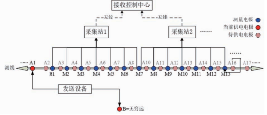
FIG. 2 Schematic diagram of SSIP two-sided pole-dipole sounding
In this setup, the spacing between measurement points is 10 meters, with a measuring electrode distance (MN) of 20 meters, and the minimum to maximum power supply electrode spacing (A0) is from 15 to 1500 meters. The transmission uses a 5th-order spread spectrum square wave signal with four frequency components, with a base frequency of 1/16 Hz and a supply current between 1.0 and 8.5 A.
After completing SSIP data acquisition, inversion is performed using ZondRes2D software, which has been optimized multiple times to accommodate the SSIP survey method. It allows inversion of SSIP data for any combination of power supply and measurement electrodes. The selected inversion method for this study is Occam inversion, with 10 iterations. Based on the variation range of the apparent polarization rate and the electrical properties of rocks in the survey area, the upper limit for the polarization rate was set at 10%. In terms of subdivision, the initial layer thickness was set to 10 meters, with an increase factor of 10%, totaling 30 layers and a maximum inversion depth of 823 meters. The results indicate that the errors for resistivity and polarizability inversion are within acceptable limits, allowing these results to be used for interpretation and drill hole positioning.
4. Results Interpretation
Since the polarization characteristics of the target body are more prominent than its resistivity features, the anomaly interpretation primarily relies on polarizability inversion results, with resistivity inversion results as a supplementary reference.
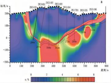
From the polarizability inversion profile (Figure 3), several discontinuous high polarization anomaly bodies can be observed at horizontal distances of 125 meters (elevation +150 meters), 200 meters (elevation +50 meters), segments from 300 to 450 meters (elevation -100 meters), 600 meters (elevation 0 meters), 725 meters (elevation +50 meters), and 800 meters (elevation +175 meters). The anomaly intensity reaches 10.0%, while the surrounding rock background averages around 1.0%, marking a 10-fold difference. These anomaly bodies are strong and stable, exhibiting an overall downward-concave band-like structure.
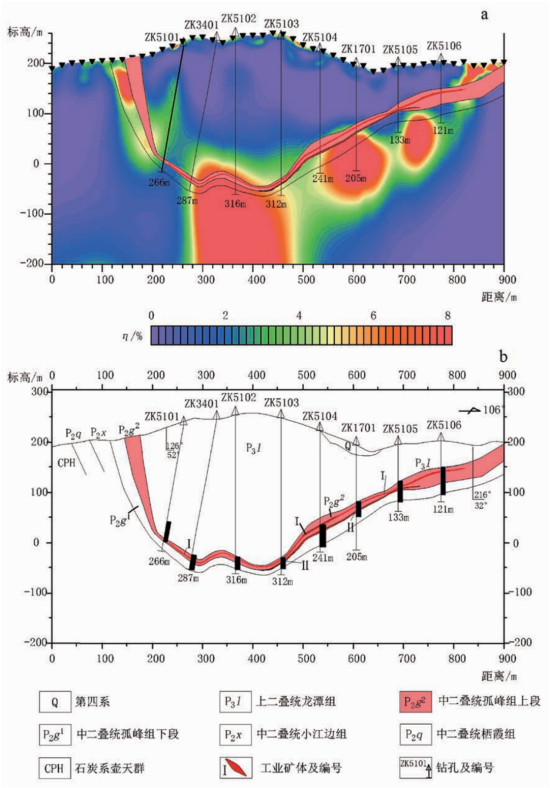
FIG 3. Spread spectrum IP polarizability (a) and geological profile (b) of T51 line
On the resistivity profile (Figure 4), within the 100 to 900-meter horizontal distance and from -50 meters to the surface elevation, there is a continuous, stable low-resistance zone. Below the -50-meter elevation, high-resistance areas appear. The continuous low-resistance zone represents the Upper Permian Longtan Formation (P3l) in the syncline core. The basin-shaped high-resistance basement indicates multiple high-resistance strata from the lower Middle Permian Gufeng Formation to the Carboniferous Hutian Group. The high-to-low transition zone (500–800 Ω·m) corresponds to the buried ore-bearing strata in the upper Middle Permian Gufeng Formation.
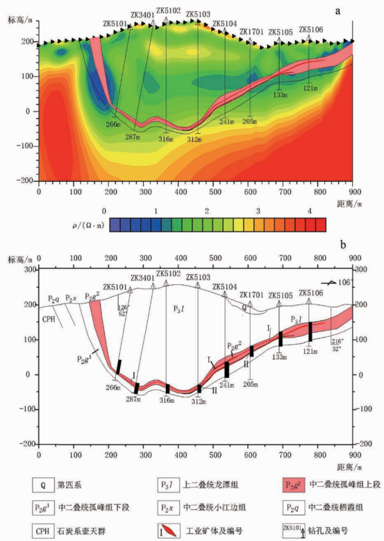
FIG 4. Spread spectrum IP resistivity (a) and geological profile (b) of T51 line
5. Drilling Results
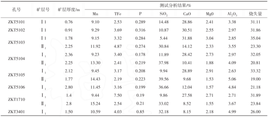
On the T51 exploration profile, eight drill holes (ZKT5101–ZKT5106, ZK1701, ZK3401) were arranged, with depths ranging from 121.5 to 316.2 meters. Manganese ore bodies, with thicknesses of 0.9 to 2.8 meters and grades of 9.3% to 15.2%, were exposed in limestone formations at depths of 222.5 meters, 284.0 meters, 281.2 meters, 187.7 meters, 85.0 meters, 59.6 meters, 281.5 meters, and 117.9 meters. The exposed ore veins were relatively continuous and stable, with their buried extent and morphology closely matching the IP anomaly zones.
Table 2 Core test results of T51 line
6. Conclusion
(1) The occurrence and distribution of manganese ore in the area are related to various metallogenic factors, primarily influenced by stratigraphic lithology, lithofacies, and structural elements. The stratigraphic orientation determines the general spatial distribution range of the deposits, the complexity of lithological composition affects the overall physical characteristics of the ore, and structural controls reshape the underground morphology of the deposit.
(2) Since the resistivity contrast with the surrounding rock is minimal and the thickness proportion of the ore layer relative to the entire ore-bearing formation is small, without a significant resistivity anomaly, the polarizability parameter can effectively delineate the spatial distribution of the ore layer. Therefore, multi-parameter measurements are an effective approach for locating manganese deposits.
(3) Drilling verification demonstrates that SSIP is effective for locating carbonate-type manganese deposits, as polarization anomalies align well with the depth, shape, and contour of the exposed ore bodies. The resistivity anomalies accurately reflect the stratigraphic distribution in the mining area, and compared to traditional IP methods, SSIP offers faster, more cost-effective results with reliable IP anomalies, making it a promising technique for future applications.
Original source: Liao Fengchu, Liu Guiyuan, Zhou Jie, Huang Jianquan, Xu Junwei, Chen Rujun. 2024. Analysis of exploration effect of spread spectrum induced polarization (SSIP) method——Taking the exploration of Dongxiangqiao manganese deposit in Lingling district,Yongzhou City, Hunan Province as an example [J]. Mineral Exploration, 15 (9) : 1691-1699.


